Mackay grew fast from the 1970s onward, with suburbs climbing the Pioneer Valley slopes and new estates pushing into the western foothills. That expansion brought a recurring challenge: cutting into ancient alluvial fans and weathered metasediments creates faces that can unzip during a wet season. We see it every year after a cyclone trough dumps 400 mm in a weekend. A proper slope stability analysis in Mackay is not a box-ticking exercise; it is the difference between a safe subdivision and a costly remediation. Before any cut or fill, we run limit-equilibrium models that account for the region's high rainfall intensity and the variable clay layers left by the old river channels. Combining that with a geotechnical drainage assessment helps us understand how water pressure builds behind the face over time. That is the kind of site-specific thinking that saves owners from future headaches.
A slope stability analysis in Mackay must account for the rapid pore pressure rise that follows a 1-in-10-year storm event, or the numbers will lie.
Methodology and scope
On site we mobilise a rig capable of continuous core sampling to 30 metres, even on the steeper lots near Blacks Mountain. The setup includes a wireline system that recovers high-quality samples from the weathered zone where most failures initiate. For the slope stability analysis itself we use software that runs Bishop simplified and Morgenstern-Price methods, so we can handle non-circular surfaces common in Mackay's residual soils. The equipment also carries a piezometer string to log pore pressure in real time. Here is what the typical field programme looks like:
Percussion drilling with SPT at 1.5 m intervals down to refusal
Installation of standpipe piezometers in the colluvium layer
Undisturbed tube sampling at each change of stratum
In-situ shear vane testing within the soft clay zones
The data feeds directly into our limit-equilibrium models. We have calibrated these against three back-analysed failures in the Eungella road corridor, so the predictions are grounded in local precedent.
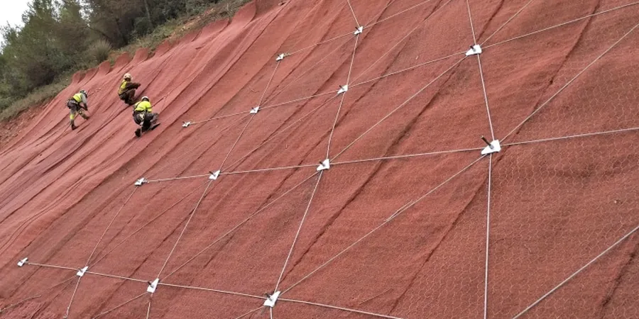
Technical reference image — Mackay
Local considerations
A few years back we got called to a housing estate in Mount Pleasant where a 9 m cut slope had started creeping after three consecutive wet months. The original report had used a dry-season groundwater table and a factor of safety of 1.3. By the time we arrived, the tension cracks were half a metre wide. We re-ran the slope stability analysis with measured pore pressures and got a factor of safety of 0.98. That slope needed immediate unloading and a subsurface drain system. The lesson was brutal but useful: in Mackay, the water table can rise 4 metres in a single week. Ignoring that transient condition turns a stable cut into a liability. Our protocols now always model a wet-season worst case, backed by field piezometer data collected over at least one full wet cycle.
Bishop and Morgenstern-Price analyses for circular and non-circular failure surfaces. We input site-specific strength parameters from triaxial and direct shear tests run in our NATA-accredited lab.
02
Pore Pressure Monitoring
Installation and monitoring of vibrating-wire piezometers across the slope profile. Data logged hourly during the wet season to capture transient peaks that drive instability.
03
Remediation Design
If the factor of safety falls short, we design soil nails, drainage blankets, or buttress fills. All designs comply with AS 4678 and include construction supervision.
Applicable standards
AS 4678-2002 (Earth-retaining structures), AS 1726-2017 (Geotechnical site investigations), AS/NZS 1170.4-2007 (Structural design actions – earthquake)
Frequently asked questions
How much does a slope stability analysis in Mackay cost?
For a typical residential cut slope (up to 10 m height), the study including drilling, lab testing, and modelling ranges from AU$1,690 to AU$6,090. Larger mining or infrastructure slopes cost more depending on the number of sections and monitoring duration.
What factor of safety do you recommend for Mackay's climate?
For permanent cuts we target 1.5 under static conditions and 1.1 under seismic load as per AS 4678. Because of the intense tropical rainfall, we also check the short-term case with fully saturated soil and a pore pressure ratio of 0.4.
How long does a typical slope stability study take?
A standard residential assessment takes three to four weeks. That covers one day of drilling, two weeks for soil testing in the lab, and one week for modelling and reporting. Wet-season delays can add a week if the site becomes inaccessible.
Do you include groundwater monitoring in the analysis?
Yes, always. We install at least two standpipe piezometers per slope section and log levels weekly for a minimum of one month. For high-risk sites we use automated loggers that record every hour during storm events.